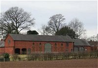
Farmsteads
Our Historic Environment Team has been involved in a series of projects aimed at better understanding and managing historic farmsteads within Staffordshire and the wider West Midlands region.
This work has included:
Staffordshire Farmsteads Guidance
Staffordshire County Council in conjunction with Historic England have produced guidance to help inform and achieve the sustainable development of historic farmsteads in Staffordshire, including their conservation and enhancement.
The guidance comprises 3 documents:
The Farmstead Assessment Framework
This provides a step-by-step approach to considering the reuse of traditional farm buildings and the sustainable development of farmsteads, through identifying their historic character, significance and potential for change.
Please note: The PDF above may not open in Internet Explorer. To view it, right-click on the link and save the document by selecting 'save target as'. Then open it from the place you have saved it.
Staffordshire Farmsteads Character Statement
This includes an introductory summary followed by fully illustrated guidance on the character and significance of the county’s traditional farmsteads and buildings. It includes sections on the historic development, landscape and settlement as well as guidance on identifying traditional farmsteads and building types, materials and architectural details. The final section provides summaries based upon nine areas into which the county subdivides based on analysis of its traditional farmsteads in their landscape context.
Please note: The PDF above may not open in Internet Explorer. To view it, right-click on the link and save the document by selecting 'save target as'. Then open it from the place you have saved it.
Local authority summaries
These provide guidelines for planners and applicants by local planning authority area.
They cover:
- Cannock Chase District
- East Staffordshire Borough
- Lichfield District
- Newcastle Borough
- South Staffordshire
- Stafford Borough
- Staffordshire Moorlands District
- Tamworth Borough
The summaries are below:
Please note: The PDFs above may not open in Internet Explorer. To view them, right-click on the link and save the documents by selecting 'save target as'. Then open them from the place you have saved them.
These documents are aimed at:
- Local authority planners
- Owners of traditional farm buildings
- Professionals involved in planning or conservation of historic buildings
The character statement may also be useful for those interested in Staffordshire’s agricultural history.
If you have any queries please contact us on her@staffordshire.gov.uk
In 2009 Forum Heritage Services undertook a project on our behalf to map all farmsteads across the county.
The project was funded by Historic England as part of a wider project mapping historic farmsteads across the West Midlands region and the whole of England (see the Historic England website for more details).
The aim was to provide a consistent understanding of farmstead character and survival at a landscape scale within Staffordshire, in order to inform policy and interpretation.
The collation and analysis of data in the project is being used to:
- Inform land use policy and planning (including supplementary planning documents).
- Develop the information base held within the Staffordshire Historic Environment Record.
- Inform local development frameworks and to provide the context and guidance for applications relating to individual historic farm buildings.
- Contribute towards the understanding of the sustainability of rural settlements.
- Informed the targeting of environmental stewardship and to assist landowners, managers and advisors with applications and Farm Environment Plans (FEPs).
- Develop a more integrated approach towards the understanding and management of farmsteads in their landscape context.
- Explore means of utilising redundant farmstead buildings for commercial and residential use.
 The project recorded all farmsteads within Staffordshire that are shown on the Ordnance Survey second Edition 25" mapping of circa 1895.
It included information on specific attributes for each farmstead including plan form, condition, the location of the farmstead in relation to settlement and the date of earliest building derived from listed building data.
The identification these attributes followed the methodology set out in 'Historic Farmsteads - A Manual for Mapping'.
Over 70% of farmsteads identified survive with relatively low degrees of change (with only 17% no longer recognisable as historic farmstead sites). Many farmsteads retain considerable character with traditional farm buildings either in agricultural use or redundant but unconverted. Although this survival is high compared to many parts of the country, a lower proportion of the farmsteads retain agricultural buildings pre-dating the eighteenth century and very few have farm buildings of medieval date.
The outputs of the survey included a map layer (for Geographic Information Systems (GIS)) providing information on the location, survival and farmstead type, a summary report and an associated manual for mapping.
Please note: The PDFs above may not open in Internet Explorer. To view them, right-click on the link and save the documents by selecting 'save target as'. Then open them from the place you have saved them.
West Midlands Farmsteads and Landscape Project
The West Midlands Farmsteads and Landscapes Project was conducted by English Heritage (now Historic England) in collaboration with regional development agency Advantage West Midlands and local county and metropolitan authorities. It helped national and local decision-makers evaluate what future uses for farm buildings should be and to identify the most significant and vulnerable cases.
For the first time at a regional level the project has:
- Mapped and described the locations and characteristics of all farmsteads, their change over time, and how they relate to the landscape.
- Described the present day role of historic farmsteads in the West Midland’s economy.
- Developed a set of planning tools to inform spatial planning, land management and economic development.
A series of documents produced as a result of this project, including:
- A summary report.
- The West Midlands area farmstead character statements.
- An introduction and overview to current historic farm property in the West Midlands.
- Regional and county historic farmsteads web pages.